


Heat
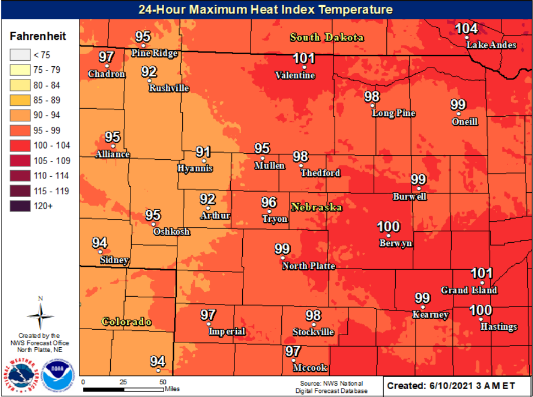
Heat indicies to near 100 degrees today. Areas generally east of a line from Enders Reservior to Seneca and east of Kilgore between 1 PM to 8 PM. Take extra precautions if you work or spend time outside. When possible reschedule strenuous activities to early morning or evening. Know the signs and symptoms of heat exhaustion and heat stroke. Wear lightweight and loose fitting clothing when possible.
To reduce risk during outdoor work, the Occupational Safety and Health Administration recommends scheduling frequent rest breaks in shaded or air conditioned environments. Anyone overcome by heat should be moved to a cool and shaded location. Heat stroke is an emergency! Call 9 1 1.
Severe Weather
Hazards: Large hail (> 1” in diameter), strong winds (> 60 MPH), and heavy rainfall along with frequent lightning.
Areas Impacted: Enhanced risk of severe weather covers most of our area with a Slight risk for far southwestern areas and southeast Panhandle. Timing & Duration: Isolated to scattered thunderstorms will develop over the panhandle this evening and increase in coverage while moving into western and north central Nebraska.
The severe threat appears after 7 PM CDT across the Panhandle and far northwestern Nebraska. Storms may quickly become severe, forming a line of storms and tracking to the south and east overnight. Thunderstorms and the severe threat may linger into the early morning hours Friday with a damaging wind concern continuing until activity clears the north central.
Impacts: Property damage and power outages possible. Persons that are outdoor should closely monitor the weather situation and be prepared to quickly seek shelter if threatening weather approaches.