


Four wildfires in Nebraska continue to see response from firefighting crews after sparking late last week. Updates continue to roll in at different rates for each. Below we will update what is known as available through the day Tuesday (March 17).
Firefighters expect fire activity to increase today with a red flag warning in effect. Northwest winds are expected to reach 50 MPH with temperatures in the 70s.
Any news on the four major fires in Nebraska received through the day Tuesday will be placed into this story through updates.
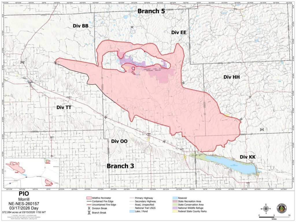
Morrill Fire
Began: Morrill County due to a power pole knocked down by wind, March 12
Where: Has affected or threatened land in the counties of Morrill, Garden, Grant, Arthur, and Keith
Acres burned as of this update: 572,084
Containment as up this update: 18%
Latest additional information or explanation: Monday, local volunteer firefighting crews completed the containment line on the southwest side of the fire in Division TT. Today, crews will continue engaging areas of active fire while strengthening containment lines and mopping up. Some fire remains in the cottonwood areas and areas with cottonwoods and cattails on the north side continue to hold some heat. Two drones will be available Tuesday.
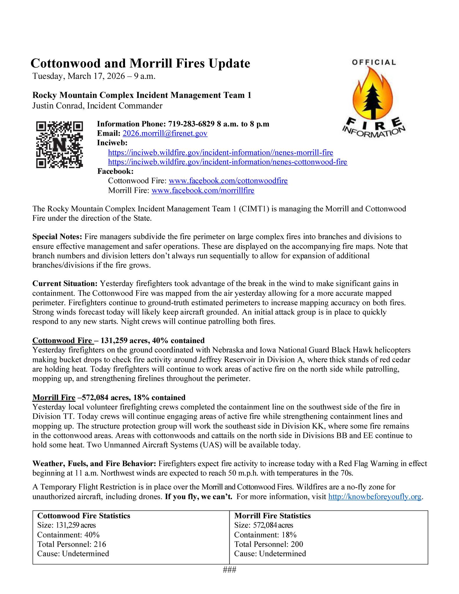
Cottonwood Fire
Began: Southeast corner of Lincoln County near Cottonwood Road and South Government Pocket Road, March 12
Where: Has affected or threatened land in the counties of Dawson, Lincoln, and Frontier counties
Acres burned as of this update: 131,259
Containment as of this update: 40%
Latest additional information or explanation: Through Monday, firefighters on the ground coordinated with Nebraska and Iowa National Guard Black Hawk helicopters making bucket drops to check fire activity around Jeffrey Reservoir in Division A, where thick stands of red cedar are holding heat. Through Tuesday, crews will work areas of active fire on the north side while patrolling, mopping up, and strengthening fire lines throughout the perimeter.
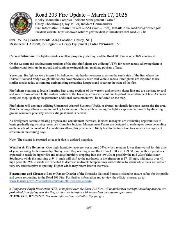
Road 203 Fire
Began: When the Chokecherry Prescribed burn at the Halsey National Forest left its burn area two days later, March 12
Where: Has affected or threatened land in the counties of Blaine, Logan, Thomas, and Custer
Acres burned as of this update: 35,386
Containment as of this update: 36%
Latest additional information or explanation: Firefighters made excellent progress on Monday and containment rose. On the western and southwestern portions of the fire, firefighters are using UTVs for better access. Some firefighters were inserted by helicopter into harder-to-access areas on the south side of the fire, where the Dismal River and bridge weight limitations had been restricting vehicle access. Similar tactics are expected to be used today. Lingering heat along the western and northern dozer lines are going to be cooled and secured. East, crews are patrolling the containment line. Drones will continue to be used to identify hot spots. Managers are evaluating opportunities to begin gradually right-sizing resources by scaling up or down depending on what the incident needs. A smaller management structure is likely in the coming days.
Anderson Bridge Fire
Began: On the eastern edge of Samuel R. McKelvie National forest south of Kilgore, March 12
Where: Has affected or threatened land in Cherry County
Acres burned as of this update: 17,400
Containment as of this update: 60%
Latest additional information or explanation: Samuel R. McKelvie National Forest remains closed to visitors for safety. No further updates on Tuesday at this time.