


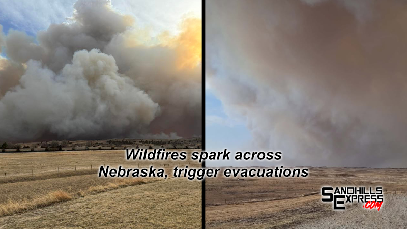
Fire departments across Nebraska are being stretched thin due to blazes of all sizes sparking before moving quickly across the land. High winds and low humidity levels forecasted days in advance throughout the state are fueling the fires.
Two fires in central Nebraska, the Road 203 Fire near Halsey and Dunning and a fire south of Maxwell named the Cottonwood fire, are drawing a large response and are the closest to our listening area. The largest fire in the state is the Morrill Fire, which began north of Bridgeport and has progressed into Arthur County and toward Lake McConaughy north of Ogallala.
All information gathered on the Road 203 and Cottonwood fires through Noon on Monday March 16th can be seen below. Updates have slowed to once or twice daily. Head to the news page of Sandhills Express for the latest on the fires.
‘Road 203 Fire’ near Halsey/Dunning
The Nebraska National Forest area was site of the ‘Chokecherry Prescribed Burn’ earlier this week south of Forest Service Road 203 and west of Forest Service Road 212. Ignitions were concluded on Tuesday afternoon and the fire was in monitoring status.
According to Nebraska National Forests and Grasslands, Thursday afternoon around 4 PM fire activity spread outside the project area. The resulting fire was declared the ‘Road 203 Fire’.
Just before 6 PM, residents of the community of Dunning were advised to evacuate by Region 26 Emergency Management. The Anselmo fire hall was opened at that time as a safe place to go. Some 10 to 15 minutes later, the evacuation advisory was lifted as the fire quickly shifted south.
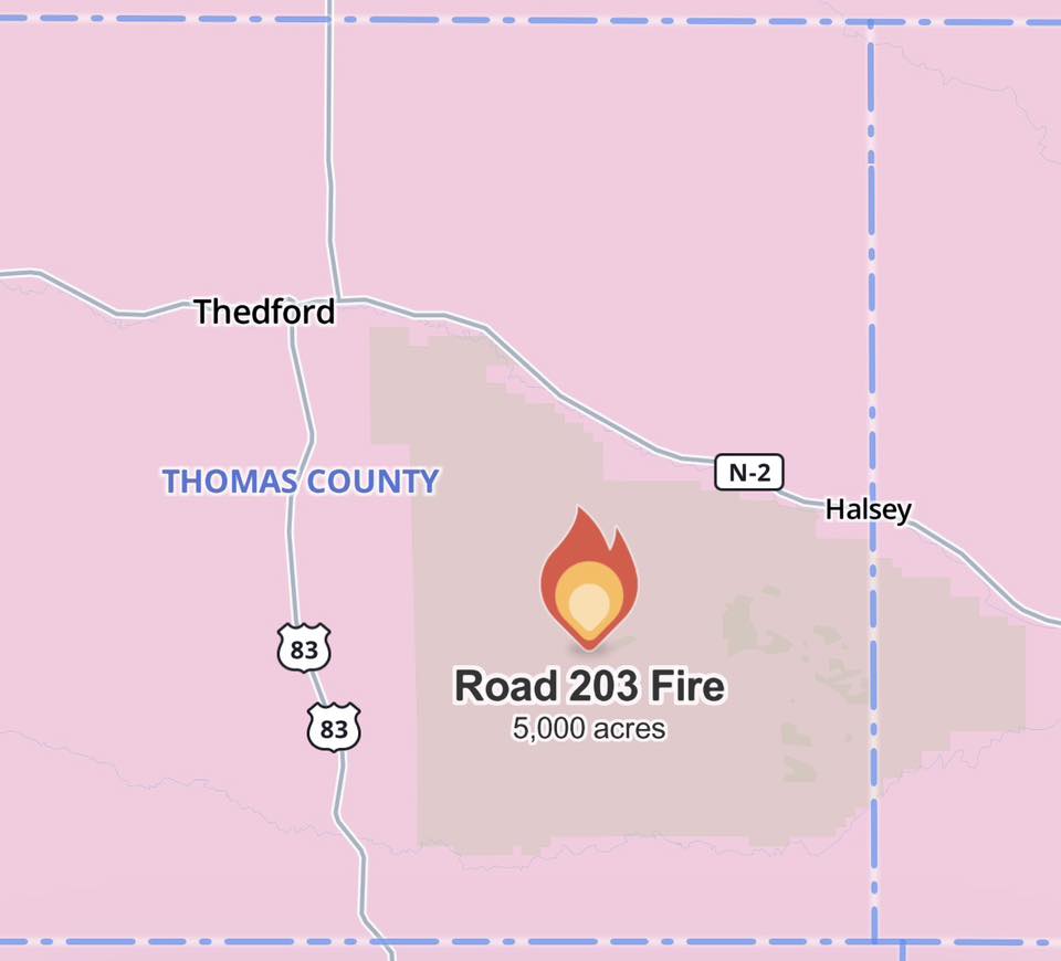
Less than a half hour later, around 6:30 PM, the ‘Road 203 Fire’ had burned more than 5,000 acres along its path to the southeast. The was stated to still be growing, per incident information updates.
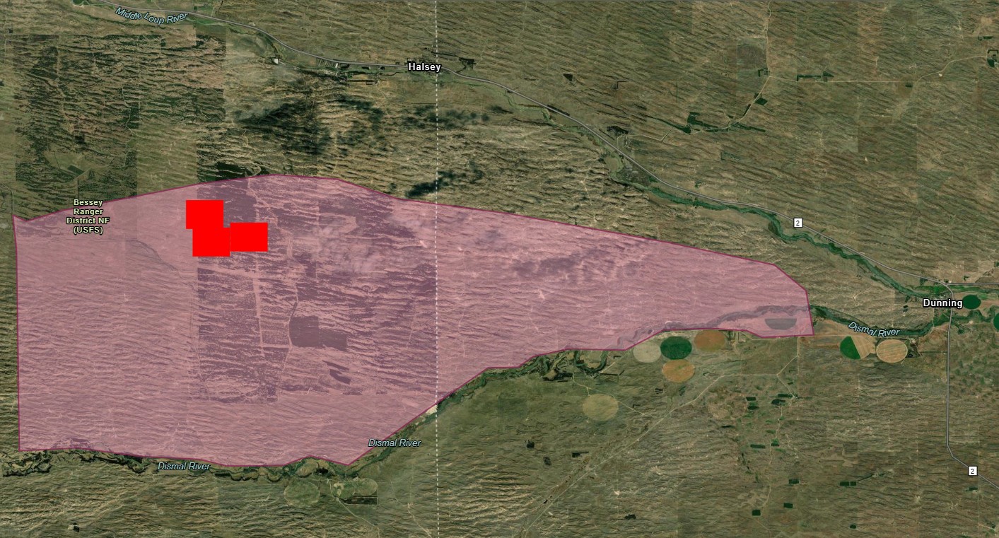
By 8:30 PM, the National Oceanic and Atmospheric Administration’s (NOAA) wildland fire data portal showed that the fire had traveled far enough that it was across the Blaine County line to the east and in close proximity to the Logan County line to the south. The northwest corner of Custer County was being approached by the fire.
UPDATE, 10:30 PM Thursday: The National Forest Service says the fire has spread an estimated 15 miles. Several dozen fire departments are on scene along with National Forest Service staff.
UPDATE, 11 PM Thursday: Incident contacts for the fire have told KCNI/KBBN that the sunset and drop in temperature have helped in firefighting efforts, but that the scene is still very much active. They also stated that an incident management team had been ordered. If this comes to be a National Incident Management activation, FEMA.gov states that the system “guides all levels of government, nongovernmental organizations, and the private sector to work together to prevent, protect against, mitigate, respond to and recover from incidents.”
UPDATE, 11:15 PM Thursday: An approximate fire perimeter indicated on the Fire Information for Resource Management System (FIRMS) holds approximately 35,000 acres inside.
UPDATE, 8:00 AM Friday: Fire weather concerns continue today and Saturday as well above normal temperatures, dry air, and gusty winds persist across much of the state. Relative humidity levels predicted by the NWS show a dip into the 20’s and below for Friday afternoon and Saturday afternoon.
Precipitation in the form of rain that will quickly turn to snow is predicted for late Saturday evening right now, although with strong winds into the 50 MPH range. Snowfall will favor the northern part of the state with between 1″ to 5″ predicted for the areas of Gordon, Valentine, Ainsworth, Butte, and O’Neill.
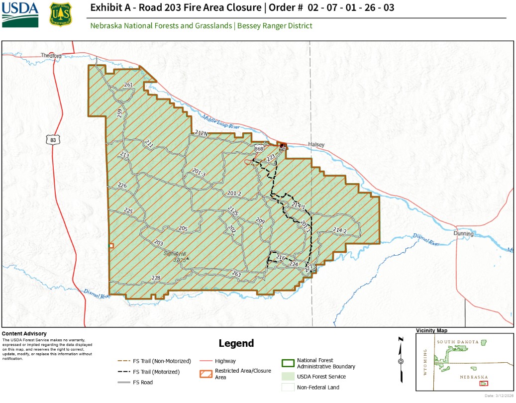
UPDATE, 11:30 AM Friday: The Bessey Ranger District has temporarily closed the Nebraska National Forest and the Samuel R. McKelvie National Forest near Valentine due to the Road 203 and Anderson Bridge Fires. The closure was stated to be for the safety of both the public and emergency responders.
UPDATE, Noon Friday: The Road 203 fire is confirmed to be at 35,000 acres. Crews are continuing to secure the perimeter to keep spread from getting closer to the Middle Loup River and the town of Dunning.
UPDATE, Friday afternoon: Governor Jim Pillen has issued an Executive Order that bans the issuance of open burn permits for 14 days. Fire chiefs or any person designated by the fire chief are prohibited from granting an open burn permit for any purpose. Any existing burn permit that has not been completed is null and void. The order will be reviewed prior to its termination to determine the need to extend the ban. For now, the ban exists until 11:59 PM on March 27.
REMINDER: The area of this fire is contained within a red flag warning and high wind watch area for Saturday. Wind gusts as strong as 60% and afternoon humidity as low as 10 to 20% are possible.
UPDATE, 4:35 PM Friday: Due to its location, the fire is currently being managed by federal authorities. Updates have slowed and are intermittent. The fire is being contained at the moment.
UPDATE, 5:20 PM Friday: The fire is now 37,468 acres according to the perimeter on the National Interagency Fire Center.
UPDATE, 10:30 AM Saturday: (See Road 203 Fire Update for full update description) The Road 203 fire has grown to nearly 37,000 acres and is 0% contained. Extreme winds the past two days have driven significant fire activity and growth. Direct attacks are being used where possible and dozer lines being built reinforced with aerial retardant drops are being utilized while structure protection teams defend buildings.
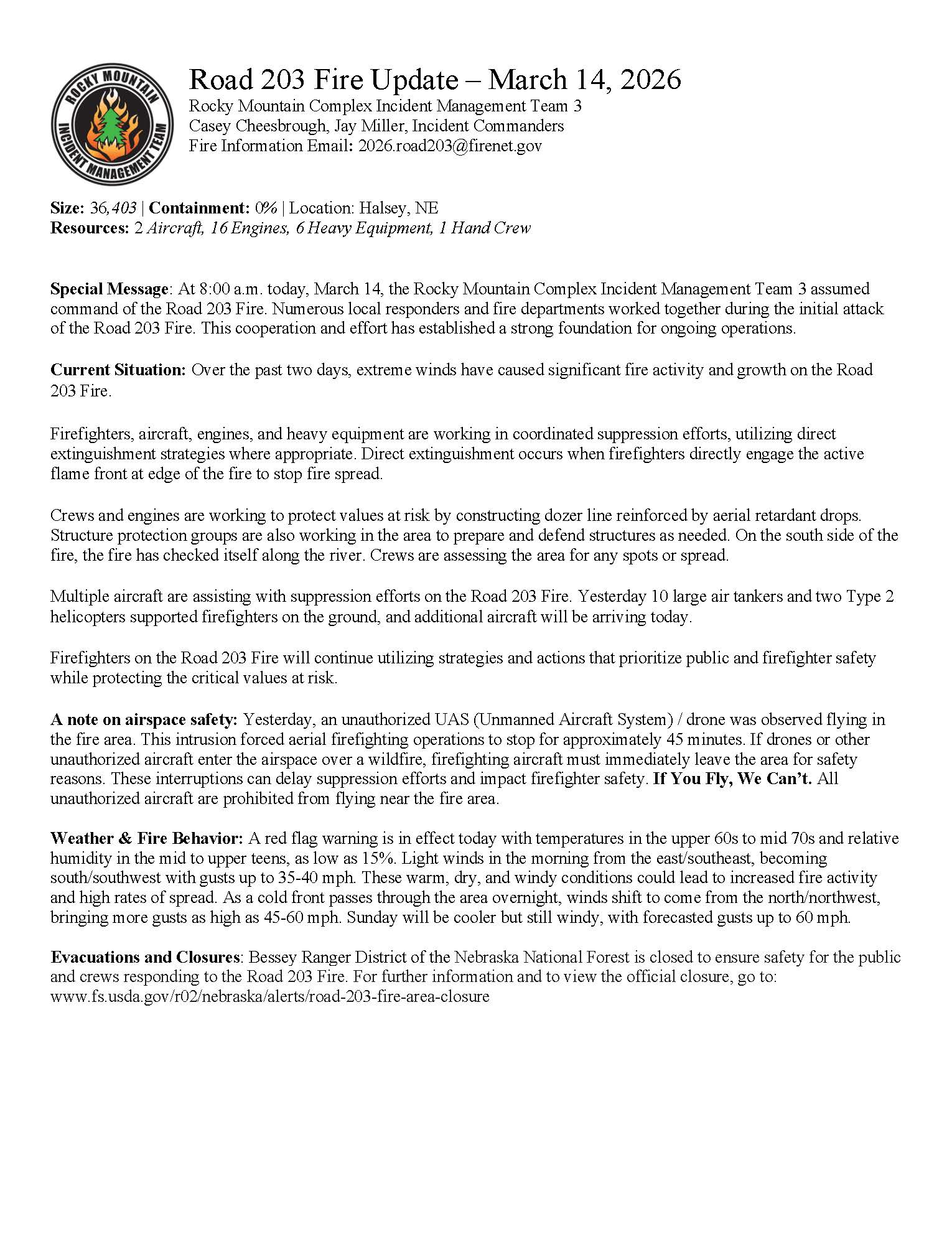
On the south side, the fire has checked along the river and crews are monitoring for spread. Multiple aircraft are supporting ground crews including 10 large air tankers and two type 2 helicopters yesterday, with more aircraft/engines/heavy equipment expected.
Unauthorized drone flights forced aerial operations to stop for 45 minutes. “If you fly, we can’t” safety rule is reminded of. Red flag warning remains in effect. A cold front will bring north to northwest gusts of 45 to 60 MPH and continued windy conditions Sunday. The Nebraska National Forest remains closed.
UPDATE, 10 PM Saturday: 36,405 acres burned with 0% containment. A cold front will move through the area overnight bringing colder temperatures and increased winds.
UPDATE, 9:45 AM Sunday: Size still similar to last night, just over 36,000 acres. Overnight, snow fell on the fire area combined with increased winds. Weather conditions have deteriorated and created hazardous driving conditions.
The fire remains on the north side of the Dismal River as firefighters continue to patrol the perimeter and check for remaining heat. Mop-up operations have begun on the south side of the fire, which includes locating and extinguishing remaining areas of heat.
Due to colder temperatures expected today and tomorrow morning, crews plan to utilize an infrared-capable UAS (drone) during the early cooler daytime hours when heat signatures will be more easily detected.
While cooler temperatures and higher humidity will help limit fire spread and spotting potential, fire activity remains possible in light, flashy fuels when winds align. Sunny and drier conditions return Monday with temps warming through the week and reaching the 80s by mid-week.
UPDATE, 5:45 PM Sunday: The team in charge of the Road 203 fire put out an explanation as to why the percentage of containment has not changed on the fire. They explained that containment is reached when fire managers have a high level of certainty that natural or man-made features, like roads and dozer lines, will stop the fire from spreading (known as containment lines).

Containment lines must be cool to the touch before being called on a portion of the fire. Firefighters place their bare hands in the dirt and ash to test for areas of heat. When any percentage of containment is reached along the edge of the fire, crews continue patrolling to ensure the fire doesn’t move past them.
Snow fell on the Road 203 fire on Sunday as crews improved man-made firelines with heavy equipment. Rapidly changing weather conditions in the area are causing fire managers to be thoughtful in calling areas of the fire contained.
UPDATE, 8:00 AM Monday: Operations were limited on Sunday due to cold weather conditions. Heat is still present in the duff, and creeping fire behavior has been observed within the perimeter. Cedar trees in some areas are also retaining heat.
Yesterday, firefighters used drones with infrared technology to find hotspots and relayed that info to crews on the ground so they could extinguish those areas. Two drones will be used today to continue that operation.
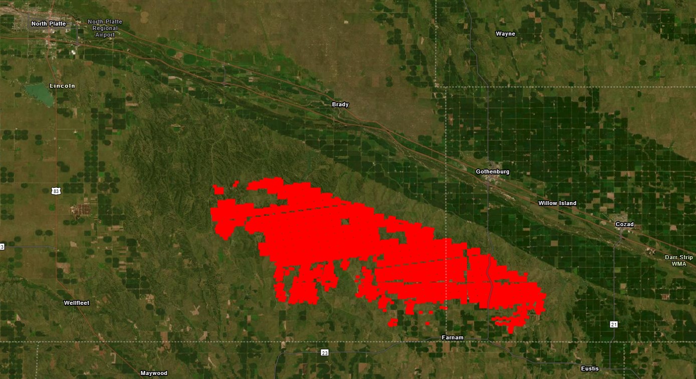
Today’s acreage count (35,814) is due to updated mapping). Response resources include two aircraft, 24 engines, 5 heavy equipment, and 160 personnel. The Nebraska National Forest remains closed to the public and a temporary flight restriction also remains in place over the Road 203 fires. UPDATED ROAD 203 MAP HERE
We are ceasing updates in this thread, as updates have slowed to just once or twice per day. View the latest on the news page of SandhillsExpress.com
Cottonwood fire
In the mid to late part of the 4 PM hour Thursday, reports were made of a large grass fire in the southeast corner of Lincoln County. Winds were reported to be gusting into the mid-40s, moving the fire along quickly. Emergency managers directed evacuation if the homes of residents were in the path of the fire.
As the fire traveled to the southeast, evacuations were ordered several times for areas including Jeffrey Lake and the area two to three miles south of Gothenburg by 7:45 PM. Shelters were opened at the Brady Community Center, North Platte Recreation Center and Brady school providing food, water, blankets, and beds for evacuees.
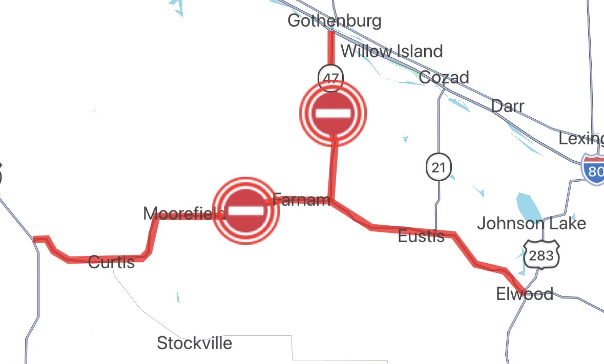
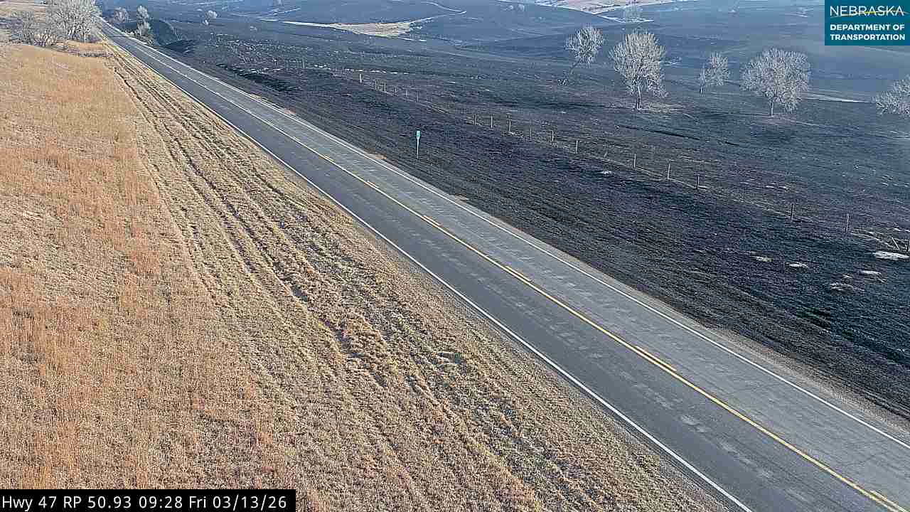
UPDATE, 8:15 PM Thursday: Highway 47 between Farnam and Gothenburg is closed due fire and responding crew presence.
UPDATE, 9:10 PM Thursday: An evacuation has been put into action for the town of Farnam, citing an expected shift in winds to the south by 10 PM. The immediate evacuation order was given by Dawson County Emergency Management and relayed by NWS Hastings, including the following statement: You should evacuate immediately to save your life. Drive east toward Eustis and wait for assistance from local authorities.
UPDATE, 10:30 PM Thursday: NOAA satellite heat signatures now cover an area approximately 30 miles in length ending just to the west of Camp Comeca southwest of Cozad. Those signatures have been moving to the south toward Farnam since the evacuation was put into place.
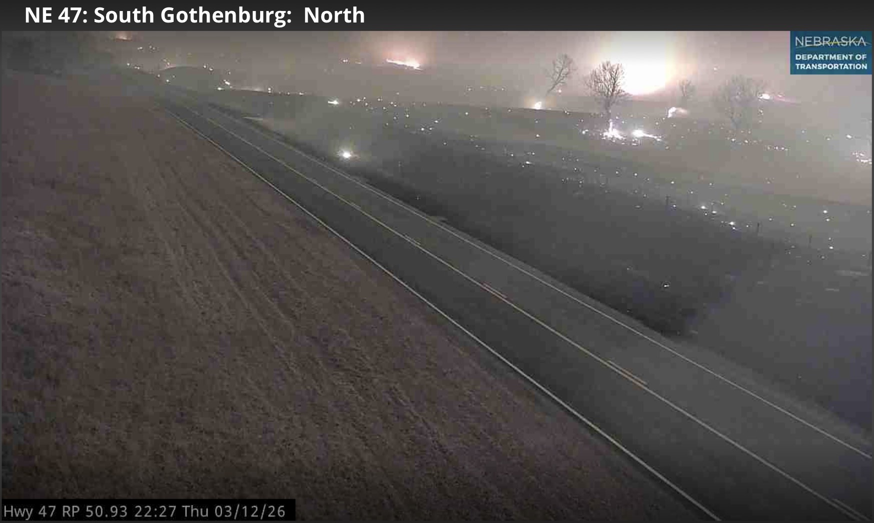
The fire could be seen on Nebraska Department of Transportation cameras on Highway 47 north of Farnam (see picture).
UPDATE, 11 PM Thursday: The Nebraska Department of Transportation has indicated that Highway 23 is closed in both directions between Maywood and Elwood. Highway 47 between Farnam and Gothenburg also remains closed.
UPDATE, 8:15 AM Friday: FIRMS mapping shows a length of travel for the fire at just under 27 miles. Overnight, Brady Volunteer Fire Department indicated that they are now the incident commander for the fire. Departments were coming from the east for a 7 AM briefing.
UPDATE, 8:45 AM Friday: Dawson County Emergency Management is advising residents of far southwest Dawson County to stay in a safe location and not return home yet as fire operations continue. This includes the town of Farnam. Highway 47 south of Gothenburg is still closed.
The wildfire is still active in the region, especially in southeast Lincoln County. There are some spot fires in Dawson County.
UPDATE, 11:50 AM Friday: A National Weather Service bulletin indicates that the evacuation order for southwest Dawson County has been lifted by local emergency management. The area is safe to return to, including the town of Farnam. Residents should be advised that fire operations are likely going to occur in the area for the foreseeable future.
UPDATE, 1:15 PM Friday: Residents of Jeffrey Lake are being told to evacuate their residences to shelter available at the Brady Community Center. Message delivered by the North Platte Police Department at the direction of emergency management.
UPDATE, 1:50 PM Friday: Those who live north of Effenback road and south of South Cottonwood road need to evacuate. The fire is moving quickly into your area.
UPDATE, Friday afternoon: Governor Jim Pillen has issued a burn ban for Nebraska through 11:59 PM March 27.
REMINDER: The area of this fire is contained within a red flag warning and high wind watch area for Saturday. Wind gusts as strong as 60% and afternoon humidity as low as 10 to 20% are possible.
UPDATE, 4:45 PM Friday: The fire has exceeded 50,000 acres and has been named the Cottonwood Fire, according to Nebraska Emergency Management Agency.
UPDATE, 3:05 PM Saturday: There has not been a confirmed update from an official source seen by KCNI/KBBN today so far.
UPDATE, 4:00 PM Saturday: The Cottonwood fire is now estimated at 100,000 acres, per Nebraska Emergency Management Agency.
UPDATE, 6:00 PM Saturday: The Rocky Mountain Complex Incident Management Team has assumed command of the Morrill County and Cottonwood fires, working alongside local officials and volunteer fire departments.
UPDATE, 10:15 AM Sunday: Fire activity increased in certain areas overnight, including between Jeffrey Lake and East Kanab Road as well as Fletcher Road. Additional units responded to those areas.
UPDATE, 7:30 PM Sunday: The fire is at 122,144 acres and 0% containment, per the National interagency Fire Center (NIFC).
UPDATE, 11:30 AM Monday: Southern edge fire activity from Sunday has been taken care of and will be mopped up today along with a search for hot spots.
Homes around Jeffrey Lake saw activity yesterday and last night. Night shift patrols were called upon to handle those and were able to take care of them right away and secure them.
As was also reported with the Morrill fire, good progress was made on Sunday in securing a perimeter around the fire.
We are ceasing updates in this thread, as updates have slowed to just once or twice per day. View the latest on the news page of SandhillsExpress.com