


After sparking late last week, four wildfires in Nebraska have had progress made on the fight against them by firefighting crews. Below are updates on what is known as it is made available through the day Wednesday (March 18).
A red flag warning is in effect for much of Wednesday for much of the area involving these fires and temperatures will reach into the mid 70s. Winds will gust into the mid-20 MPH mark and relative humidity will drop below 25% again.
Any news on the four major fires in Nebraska received through the day Wednesday will be placed into this story through updates
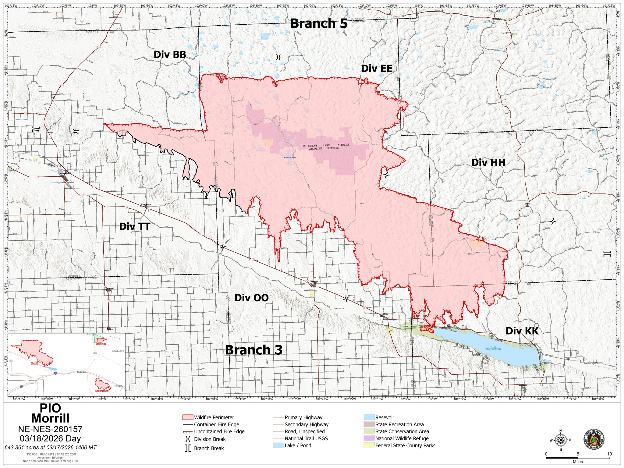
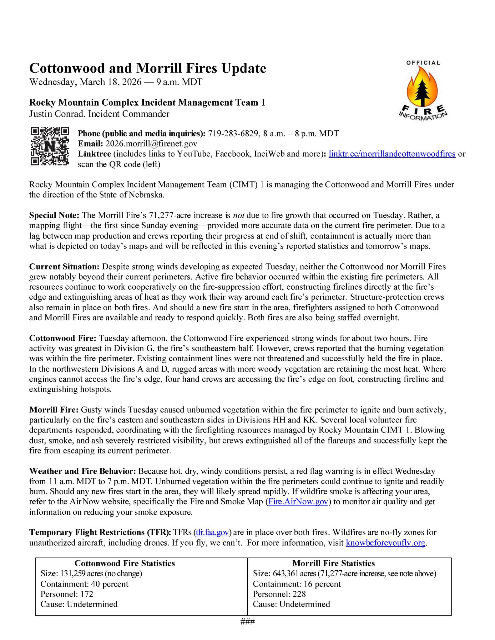
Morrill Fire
Began: Morrill County due to a power pole knocked down by wind, March 12
Where: Has affected or threatened land in the counties of Morrill, Garden, Grant, Arthur, and Keith
Acres burned as of this update: 643,361 (as of Wednesday morning.. growth in acreage is not due to fire growth from Tuesday. Rather, a mapping flight gave more accurate data.)
Containment as up this update: 16% (as of Wednesday morning)
Personnel: 228
Latest additional information or explanation: Due to a lag between map production and crews reporting their progress at end of shift, containment is actually more than what is depicted on today’s maps and will be reflected in this evening’s reported statistics and tomorrow’s maps. Gusty winds Tuesday caused unburned vegetation inside the fire perimeter to ignite and burn actively, particularly on the eastern and southeastern sides. Several local volunteer fire departments responded and handled the fire. Blowing dust, smoke, and ash severely restricted visibility, but crews extinguished all of the flareups and successfully kept the fire from escaping its current perimeter. (See full Wednesday morning update video below.. full updated maps for Morrill and Cottonwood fires at the end of this story)
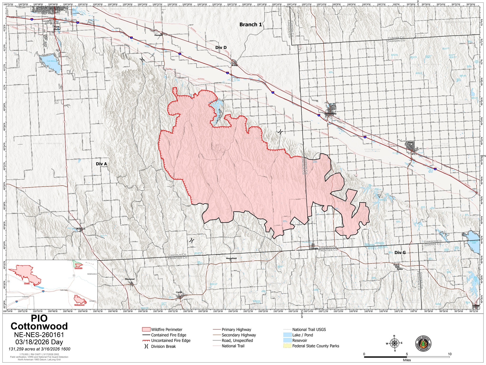
Cottonwood Fire
Began: Southeast corner of Lincoln County near Cottonwood Road and South Government Pocket Road, March 12
Where: Has affected or threatened land in the counties of Dawson, Lincoln, and Frontier counties
Acres burned as of this update: 131,259 (as of Wednesday morning)
Containment as of this update: 40% (as of Wednesday morning)
Personnel: 172
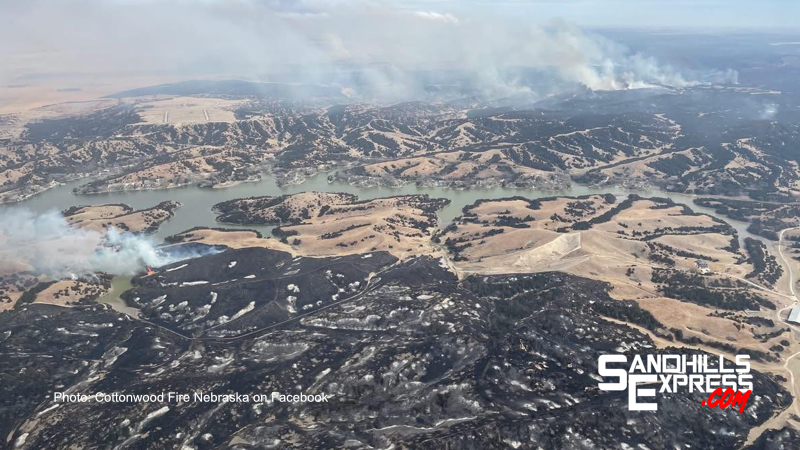
Latest additional information or explanation: Strong winds were experienced for about two hours on Tuesday afternoon. The southeastern half of the fire saw the most fire activity. Burning vegetation was inside the parimeter, however. Existing containment lines were not threatened and successfully held the fire in place. Rugged areas with more woody vegetation are retaining the most heat in northwestern divisions. Four hand crews are accessing the fire’s edge on foot where engines cannot, constructing fire line and extinguishing hot spots. (See full Wednesday morning update video below.. full updated maps for Morrill and Cottonwood fires at the end of this story)
2 PM: Several sources have confirmed that this afternoon an interior pocket of unburned fuels is being burned west of the Jeffrey Lake area, sending smoke into the air.
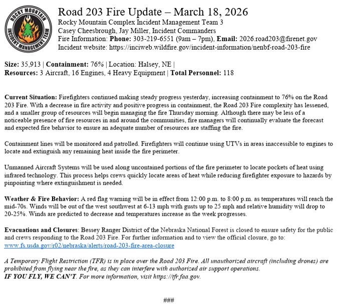
Road 203 Fire
Began: When the Chokecherry Prescribed burn at the Halsey National Forest left its burn area two days later, March 12
Where: Has affected or threatened land in the counties of Blaine, Logan, Thomas, and Custer
Acres burned as of this update: 35,913 (as of Wednesday morning)
Containment as of this update: 76% (as of Wednesday morning)
Latest additional information or explanation: Steady progress was made on Tuesday and containment increased. With a decrease in fire activity and positive progress in containment, the complexity has lessened and a smaller group of resources will begin managing the fire as of this morning. Firefighters will continue using UTVs in areas inaccessible to engines and drones will be used along uncontained portions of the fire perimeter to locate pockets of heat with infrared technology. The forest remains closed to the public and the temporary flight restriction remains in place.
Updated Road 203 briefing map here: BriefingMap 03-18-2026
Anderson Bridge Fire
Began: On the eastern edge of Samuel R. McKelvie National forest south of Kilgore, March 12
Where: Has affected or threatened land in Cherry County
Acres burned as of this update: 17,400 (as of Tuesday morning.. no change indicated so far Wednesday)
Containment as of this update: 60% (as of Tuesday morning.. no change indicated so far Wednesday)
Latest additional information or explanation: Samuel R. McKelvie National Forest remains closed to visitors for safety. No further updates on Tuesday at this time.