


March 21-25 is Nebraska Severe Weather Awareness Week. As we head into the springtime, severe weather will begin to make its way through our area. During severe weather, the Storm Prediction Center and National Weather Service will issue alerts on radios, online, and through other avenues to communicate the type of weather approaching and the possible severity. These terms can be confusing such as if you should take shelter immediately.
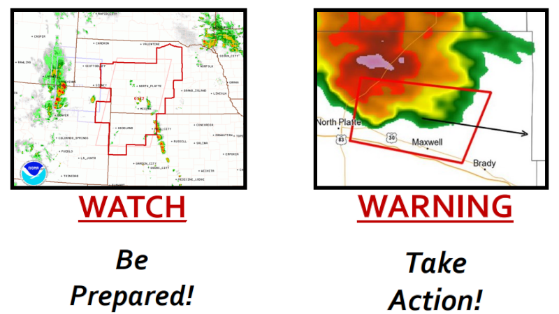
When a ‘watch’ is issued by the Storm Prediction Center the potential for severe weather is likely and could be impacting an area within a few hours. ‘Watch’ areas are typically large, covering numerous counties and even states. Those impacted by a ‘watch’ should be prepared by checking for forecast updates, monitor sky conditions, and know where to take shelter.
A ‘warning’ is issued by the local NWS forecast offices which means severe weather is imminent and you need to take shelter. Warning areas are small, perhaps a handful of counties at most. Continue to check for forecast updates, as conditions can change rapidly
Severe Thunderstorm
- A severe thunderstorm is considered “severe” when it produces:
- Quarter size (1”) or larger
- Winds of 58 MPH or higher
- A tornado
Flash Flood
- A rapid water rise that occurs with little to no advanced warning
- Usually the result of intense rainfall in a short time
- Can also be caused by dam/levee failures or ice jams
Funnel Cloud
- A funnel cloud-shaped appendage extending from a cloud
- Associated with a violently rotating column of air
- It IS NOT in contact with the ground
Tornado
- A violently rotating column of air from a cloud that IS in contact with the ground
- A tornado may not be visible until it has picked up dirt and debris