


▶ Watch Video: Severe storms wreak havoc across multiple states in the South
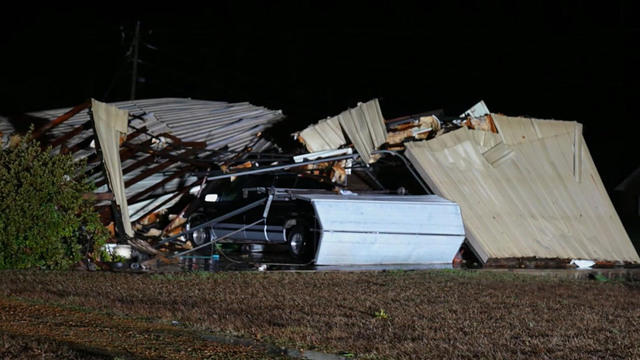
Severe weather including tornadoes, hail and damaging wind gusts hit parts of the South on Tuesday, placing an estimated 11 million people in nine states under threat. Thunderstorms roiled the region, and the National Weather Service confirmed more than 20 tornadoes across the region.
In Alabama, Montgomery City-County EMA Director Christina Thornton confirmed two tornado-related fatalities to CBS News. Both fatalities were in the same house, and a third person in the house was injured.
A little after 7 p.m. local time Tuesday, the NWS advised residents of Caldwell Parish, Louisiana, to take cover due to a “likely destructive tornado on the ground now.” At least two people were injured in that reported tornado strike, which destroyed several homes.
In Steens, Mississippi, a late-night tornado ripped trees from their roots and left homes in tatters. And in Lowndes County, one fire department wasn’t spared. It took a hit with its roof being torn off.
A ferocious downpour also hit Starkville, Mississippi, overnight. Police and first responders blocked off a rain-soaked street in the eastern part of the state, where county officials say several shoppers were temporarily trapped inside a damaged grocery store.
The severe weather began in the early afternoon Tuesday and was expected to last into the early morning hours Wednesday, according to the NWS Storm Prediction Center.
Video posted to social media Tuesday afternoon captured blistering wind gusts and hail pounding the northwest Alabama town of Muscle Shoals, while thunderstorms drenched the Morgan County area in north central Alabama. Video also showed downed trees in the west central Alabama city of Eutaw. The NWS reported that the storm that hit the Eutaw area “produced a tornado debris signature.”
The National Weather Service’s office in Birmingham, Alabama, confirmed early Wednesday morning that a twister had touched down near the border of Montgomery and Elmore Counties, urging people near Boylston to “take cover immediately!”
In Memphis, Tennessee, police and crews were busy all night. Intense rain caused enough accidents to litter highways and streets. Several of the crashes were caused by slick roads and hydroplaning.
Weather Channel meteorologist Mike Bettes said Tuesday evening there was “a high risk for some flooding across the South,” including cities like Hattiesburg, Mississippi, and Mobile, Alabama. Bettes added that Nashville, Tennessee, and Alabama cities Huntsville, Birmingham and Montgomery could also get hit hard by the storm.
The cause of the storm, according to Mike Chesterfield, director of Weather Presentation at The Weather Channel, was a cold front.
“A strong cold front will be sweeping eastward into warm moist air today into tonight helping to spawn numerous rounds of severe thunderstorms ahead of it,” he said. “The severe thunderstorm and tornado threat will be enhanced by winds which will be turning with height along with strong jet stream energy moving in overhead.”
The Mississippi Emergency Management Agency had used its Twitter account on Tuesday to warn residents to prepare for power outages and stay off the roads if possible.
Manuel Bojorquez contributed to this report from Eutaw, Alabama


