


The Salvation Army’s Gene Eppley Camp, which is just south of Omaha near U.S. Highway 75, looks to be a total loss after the nearby Platte River flooded.
The camp sits on the north bank of the Platte between Bellevue and Plattsmouth. It was inundated by floodwaters on Saturday, a Salvation Army spokesman said.
“Water levels have reached all the way up to the roofs of the cabins and other buildings,” said Todd Andrews, the spokesman.
An initial survey of the property indicates the Eppley camp, which sits on 118 acres, is a “total loss,” the Salvation Army said.
Some 3,400 people were scheduled to use the camp this year, which for decades has been a year-round camp.
The Salvation Army said it is looking for volunteers to assist with flood-relief efforts. To volunteer, people can call 402-989-6050. People also can donate by going to a special website set up for flood disaster relief.
Parts of Iowa see at least temporary improvement, while some wait for the worst
Residents of parts of western Iowa got good news Friday as high waters receded a bit, although they remained watchful in case the water rose again.
Others, such as those in Fremont County, braced for flood conditions to get even worse.
A mandatory evacuation in Missouri Valley was lifted about 11 a.m. Friday for most of the 1,000 or so people who had evacuated because the Boyer River was flooding on the south edge of town, Mayor Shawn Kelly said.
But about 150 to 200 people remained unable to return to their homes Friday evening, Kelly said. The river was receding, but officials were saying it could rise back to Thursday’s levels, he said.
The town’s Rand Community Center had been set up as a temporary shelter, but only about 15 people stayed there Thursday night.
David Pearson, a National Weather Service hydrologist, said many smaller rivers in western Iowa were going down. But he warned that some areas close to the Missouri River could see the still-rising Missouri back up into the tributaries — a rare occurrence but one worth monitoring.
Many communities along the Missouri faced closed roads and evacuations from flooding Friday — and prepared for even worse.
Those below Nebraska’s Platte River were especially vulnerable and could see “extreme” flooding, Pearson said.
Residents of Bartlett, in Fremont County, were evacuated late Thursday when water began seeping over a nearby levee, said Mike Crecelius, the county’s emergency coordinator.
Others, in the Percival area, began evacuating Friday morning when a Mills County levee near the county line was breached, Crecelius said.
Getting out of Fremont County was becoming increasingly difficult, he said, as flooding forced multiple road closures, including Interstate 29 and Iowa Highway 2.
The Missouri River near Nebraska City had already topped the 28.2-foot level it reached in during the 2011 floods, Crecelius said, and the river’s crest had yet to arrive from upstream.
Ricketts warns not to wait to be told to evacuate
At a press conference in Fremont Saturday morning, Gov. Pete Ricketts said what’s happening is an ominous sign for those downstream, who are likely to face flooding.
Ricketts and other state officials said people should consider leaving preemptively — don’t wait to be told to evacuate.
And the National Weather Service said areas like Ashland and Plattsmouth still face trouble today as the Platte and Missouri Rivers continue to rise.
“We’re just smashing some records on the big boys, the Missouri and the Platte,” said meteorologist Jeremy Wesely.
Water levels on the Platte, Missouri and Elkhorn Rivers have crested or are projected to crest today.
“Some of these crests could last for several days on the bigger rivers like the Missouri River,” Wesely said. “From Plattsmouth, Nebraska City, Brownsville, we’re talking about historic, record-level crests.”
30,000 sandbags placed at Offutt
Airmen at Offutt Air Force Base worked night and day Friday and Saturday, filling 30,000 sandbags to fend off rising flood waters from the nearby Missouri and Platte Rivers, according to a Facebook post from 55th Wing Commander Col. Michael Manion. Trucks laid out berms of protective sand, which was donated by the City of Bellevue.
“When the chips are down and waters are rising, military professionals know exactly what to do because of their planning and training,” he wrote in one post.
Water already has pooled around a lake and nearby campground in the southeast part of the base, Manion said, and those facilities have been closed. Offutt’s runway has been closed since Thursday evening and will remain so until 1 p.m. Tuesday, according to an official Notice to Airmen issued by the Federal Aviation Administration.
Manion said in his post that support services such as the Shoppette, commissary, gym and base exchange all remain open. Barriers and aqua dams have been set up around key buildings. Power has not been interrupted, and he said the base’s water has been tested and is safe.
The water was expected to crest near the base late Saturday, Manion said.
***
M.U.D. monitoring river conditions; drinking water still safe, utility says
The Metropolitan Utilities District of Omaha, which provides water to the metro Omaha area, is monitoring conditions on the Missouri and Platte Rivers but said drinking water still meets all state and federal regulations.
“Precautions are in place to protect the reliability of our water treatment and distribution systems,” the utility said in a press release. “We are closely monitoring all of our facilities and have contingency plans in place to address any issues that might occur.”
***
No disruption to flights at Eppley Airfield
The Omaha Airport Authority said Saturday that flight operations at Eppley Airfield have not been affected by flooding — flights are arriving and departing as usual.
“Access to the airport is also open, though travelers should be mindful of regional road closures if coming to Eppley Airfield,” a news release said. “The Omaha Airport Authority will continue to monitor Missouri River levels.”
***
Mandatory evacuation still in effect in Fremont as work begins on patching levee breaches
Two levees near Fremont have breached, causing surging floodwaters to find a new path through the southern part of the town Saturday morning, said Fremont city administrator Brian Newton.
Residents have put dirt and sandbags about two to three feet high on Military Avenue to prevent the water from entering the town further.
Officials are telling the couple hundred residents in the Davenport neighborhood, which is south of the Fremont Municipal Airport, to evacuate as a precaution, but there is no water in that area yet, Newton said.
Areas south of the railroad tracks, including the Inglewood area, have been flooded since Friday, Newton said.
“(Water) always tries to seek a path, so that’s what it’s doing,” he said. Read the full story here.
“There is no way out of here unless you’ve got a helicopter”
Pastor Mike Bitter of Christian Church of Waterloo said the town of Waterloo is generally dry, but people are stuck there with no traffic in or out.
“There is no way out of here unless you’ve got a helicopter – or a boat,” Bitter said.
The levees in the vicinity are holding, he said. A horse rancher asked Bitter if he could place his horse trailer in the church parking lot. Bitter said yes.
Many people evacuated Waterloo Friday while they could still get out, he said.
He and his wife, Ruth, intend to help however they can. They’re holding a prayer service at 6 p.m. Saturday for people affected by the flood.
“We’re doing OK,” he said. “We’re just so glad we’re here.”
Don’t sightsee the floodwaters, authorities warn
City of Omaha officials urged residents not to “sightsee” the flooded rivers or drive through barricades in western Douglas County.
Omaha police officers will be along the Missouri River levee in the city limits to prevent anyone from nearing the dangerous floodwaters.
Anyone caught driving around or through barricades in Madison or Stanton counties will be ticketed or arrested, officials said.
“Please PLEASE confine your sight-seeing to social media and news outlets, said Jon Downey, an investigator for Madison County Sheriff’s Office. “Rescue and recovery efforts are hard enough without tourists interfering by being in the way.”
The Douglas County Sheriff’s Office also plans to ticket anyone driving around barricades on closed roads around Valley and Waterloo, said Capt. Wayne Hudson.
***
Bellevue neighborhoods near Offutt and Missouri still closed
Paradise Lake and Green Acres neighborhoods in Bellevue, which are located between Offutt Air Force Base and Missouri River, continue to be closed Saturday, Bellevue Police Department said. Mission Avenue is closed east of Warren Street, and Harlan Lewis Road is closed south of West 27th Avenue.
Utilities have been partially shut off and authorities are patrolling the area to prevent people from entering. First responders are still conducting water rescues to free people who are trapped.
***
Sarpy County officials: if you live near the Platte or Missouri, get out
Sarpy County officials continued to advise residents who live near the Platte or Missouri Rivers to evacuate Saturday morning.
Power to homes in those areas may be shut off because of safety reasons, said Megan Barrett, a spokeswoman for the county.
The Sarpy County Sheriff’s Office will only attempt water rescues during the daytime, so officials say that anyone who needs rescue during the nighttime must wait until Sunday morning.
After surveying waters from helicopter, Ricketts says it’s the most damage in ‘last half-century’
Gov. Pete Ricketts surveyed the extensive flooding in eastern Nebraska by air Friday morning and characterized it as the worst in 50 years.
“This is probably the most widespread flooding damage we’ve had in the last half-century,” he said at a press conference at the Norfolk airport on Friday. “Even when we were away from the water system, we saw that the fields were very saturated.”
Ricketts surveyed the Platte, Loup and Elkhorn Rivers by helicopter with the Nebraska National Guard.
Later, at a stop at the Millard Airport in Omaha, Ricketts said state and federal officials still were compiling damage estimates from local communities. He said he’s confident Nebraska will meet the threshold to apply for federal disaster relief.
Just spoke w/ @GovRicketts. The people of Nebraska & across the Midwest, especially the Farmers & Ranchers, are feeling the impacts from severe weather. The first responders & emergency response teams have done a great job dealing w/ record flooding, high winds, & road closures.
— Donald J. Trump (@realDonaldTrump) March 15, 2019
By Thursday night, more than 20 towns and 23 counties in the state had made emergency declarations, officials said at the press conference.
U.S. Rep. Don Bacon said that in his district, the biggest areas of concern were Waterloo and Valley. Approximately 200 houses have been damaged or destroyed in Waterloo, he said.
The governor said he saw a bridge out near Genoa, water over highways and broken levees. He urged motorists to not drive over water-covered streets and to check road reports on the Nebraska 511 traveler system for closures.
Speaker of the Legislature Jim Scheer of Norfolk, who also surveyed the damage, said there isn’t enough manpower to block all roads, so if motorists see water, they shouldn’t drive through it.
“If they tell you not to go, don’t go,” he said. “It’s pretty simple, it’s not rocket science.”
Scheer said he thought flooding around Norfolk, Columbus and Schuyler was bad, but the hits just kept coming as they toured areas off the Elkhorn River.
“It’s going to be a long haul for a lot of the communities along the rivers,” he said. “The damage is just yet unknown.”
A person who was reported missing during Thursday’s flooding in Norfolk still was missing Friday. Authorities have found the person’s car, which is surrounded by water, and they will retrieve it when it’s safe to do so. Officials said the search for the person is continuing.
Bryan Tuma, the assistant director for the Nebraska Emergency Management Agency, said the river system will continue to be an issue as water flows toward the southeast corner of the state. Requests for assistance to the agency are lower than Tuma expected, although some communities are in need of potable water.
“Local officials are doing a tremendous job addressing the needs of their community,” he said.
Col. John Hudson, the Omaha district commander for the U.S. Army Corps of Engineers, said the corps is “extremely concerned” about the levees south of where the Platte joins the Missouri River. Water levels on the Missouri and the lower portion of the Platte have yet to hit their estimated peaks, he said.
“We’re expecting numerous levees between here and Kansas City to overtop over the next two to three days, and we’re still probably a good week-plus before we’re seeing relief on the Missouri River,” Hudson said.
The Nebraska National Guard rescued 34 people and seven dogs during air rescues Thursday night, said Major General Daryl Bohac.
“These are complex operations,” he said. “We’re putting a soldier on a hoist and dropping them into the area, often made more complex by trees and utility wires. These are dangerous things that are happening, but we are able to help.”
An operation to drop 1.5 tons of sandbags to place around the Lincoln water plant in Ashland was underway Friday.
For now, the Nebraska National Guard is confident it can handle the rescue and recovery operations without calling in more soldiers from out of state, Bohac said.
Emergency officials: Please evacuate before it’s too late and stay away from flooded areas
The Missouri, Elkhorn and Platte Rivers were expected Friday to crest over the weekend, but in the meantime, those who live near rivers should evacuate, emergency officials said.
And if you don’t live in those areas, stay away.
Omaha Fire Chief Dan Olsen, who is heading the Omaha-area rescue effort, said flood conditions are making rescues difficult, especially overnight.
“We’ll do our absolute best and risk it all to get to you,” he said. “But sometimes, it might not be possible.”
He and several other officials urged people to evacuate if they’re told to do so.
They said that often people’s homes are dry, so they don’t leave. Then, by the time the flood reaches the home, roads are closed.
“Things are moving and changing at a rapid pace,” Douglas County Commissioner Mary Ann Borgeson said.
Olsen noted the firefighters who were stranded in the water Thursday night. Like them, several people who have been rescued are suffering from hypothermia — some of them in critical condition.
The officials also asked onlookers to stop coming into flooded areas because they are getting in the way of first responders.
“Stop doing that,” Borgeson said. “We need our first responders to stay focused.”
Also on Friday, Omaha Mayor Jean Stothert said she had signed a local disaster declaration because of damage from severe flooding, high winds and rains since Monday in hopes of accessing emergency funds “from all available sources.”
Olsen said there’s no damage estimate yet. He estimated that at least 100 people have been involved in rescue efforts.
And near the Missouri River south of the Papillion Creek, there’s another reason to stay away from floodwater: the City of Omaha’s Papillion Creek Wastewater Treatment Plant has been shut down because of flooding, and raw sewage is going directly into the river.
That plant handles about 65 million gallons of wastewater per day, or about two-thirds to three-fourths of the wastewater in the metro area, said Jim Theiler, Omaha’s assistant public works director for environment services.
Public Works officials won’t be able to assess the damage until early next week, said Director Bob Stubbe.
And though river levels will drop after that, “We’ll see extended high flows for quite a while,” said Papio-Missouri NRD Director John Winkler.
‘The water came up pretty fast’: Extent of damage from widespread flooding starts to emerge
Highways in and out of Fremont still water-covered, closed
Saturday morning brought little relief to residents of Fremont, where roads in and out of the city are still closed.
And flash flood warnings were issued early Saturday for parts of northwest Sarpy County and east-central Saunders County.
As of 7:30 a.m. Saturday, the Dodge County Sheriff’s Office and Dodge County Emergency Management said roads in and out of Fremont, including U.S. Highway 275, U.S. Highway 30 and U.S. Highway 77, are still water-covered and closed.
Fremont city administrator Brian Newton said Saturday morning that crews would be out sandbagging because of water starting to come across Military Avenue in town.
“The Elkhorn is pretty bad,” he said. “It’s come down but not enough.”
Residents were still evacuating throughout the night, some by boat.
Grocer Hy-Vee was sending thousands of bottles and jugs of water across Nebraska to flood-ravaged communities.
Flooding has already been blamed for at least one death and two people are believed to be missing as of Friday afternoon. About a dozen injuries have been reported, including two first responders.
To check out current flooding conditions, click here. To see raw video and photos of the massive flooding around the state, click here.
***
“Worse than yesterday.”
Standing near railroad tracks near a sandbagged, flooding neighborhood in Fremont near the sandbagged, flooding West Military Avenue, Laura Griffis surveyed the destruction and took photos.
She owns 10 rental homes nearby and the tenants are all displaced. Griffs wiped a tear and said all she could do right now was bear witness, collect information and keep everyone updated.
“Worse than yesterday,” she said.
***
Nearly 900 Nebraskans in temporary shelters
On Twitter, Nebraska National Guard adjutant general Maj. Gen. Daryl Bohac shared an update that showed nearly 900 residents were staying in 18 Red Cross shelters as of Saturday morning.
The Fremont Area United Way announced Saturday morning they were opening a fourth shelter at the Church of Nazarene.
“We are in need of donations of fruit, granola bars, etc., and blankets (and) pillows to be dropped off there,” they wrote in a Facebook post. “We also need non perishable foods and blankets to go to Salem church.”
***
Flash flood warnings issued for northwest Sarpy County and east-central Saunders County
Early Saturday morning, the National Weather Service issued a flash flood warning for northwest Sarpy County and east-central Saunders County until 11:45 a.m. Saturday.
Shortly before 4 a.m., local authorities reported that the Platte River levee south of Thomas Lakes, which is north of Ashland, had over-topped.
In the Gretna area, portions of Highway 31 near South Bend and Louisville were closed Saturday morning, as well as Highway 6 to Ashland.
***
Hy-Vee donates more than 100,000 bottles of water to flooded communities
Grocer Hy-Vee is donating four semi-trucks worth of water to the American Red Cross, Nebraska/Southwest Iowa region, to distribute to the towns hardest-hit by flooding.
Saturday morning, three Hy-Vee trucks bearing water are expected to arrive at the Nebraska National Guard warehouse in Lincoln with nearly 73,000 bottles of water and more than 3,000 one-gallon jugs.
The Red Cross, the National Guard and state emergency crews will distribute the water — Nebraska emergency management officials said Friday that some towns are struggling with having enough potable water.
A fourth Hy-Vee truck is delivering more than 36,000 bottles of water to Verdigre, Nebraska.
Hy-Vee said communities that need clean drinking water should contact their local emergency management agency for more information on how to receive water.
***
DOT reports at least four bridges washed out in Nebraska
The Nebraska Department of Transportation reported that four bridges connected to the state highway system have been washed out and are damaged and impassable.
The bridges are:
» Highway 12 at Niobrara
» Highway 22 just south of Genoa
» Highway 281 just south of Spencer
» Highway 11 just south of Butte
DOT will provide detours for those bridges once floodwater go down.
The state agency advised drivers to avoid north-central and northeast Nebraska until floodwaters start to recede.
Click here to see the Nebraska Department of Transportation’s live map, or dial 511 to get the latest on road closures.
To see Douglas County road closures, Omaha Mayor Jean Stothert recommended checking dogis.org/closedroads
The Nebraska State Patrol reported late Friday that west of Omaha, part of Highway 92/Center Street had washed away.
West Dodge Road west of 204th Street was closed.
* * *
Water overtopping levies near Ashland draws evacuation calls
Communities north of Ashland were being encouraged to evacuate Friday night after water began overtopping levies, though there was not an immediate threat.
The Ashland Fire Department reported that water was spilling over levies near the communities of Wann and Big Sandy.
“We are issuing a ‘highly advisable’ evacuation to these areas to be proactive,” the department wrote on Facebook.
Water levels at the nearby Thomas Lakes had fluctuated throughout the day Friday but had not risen in the final hours of Friday.
Access to the communities remained open late Friday.
As of midnight Friday, crews had stopped monitoring water levels to rest.
Rescues include adults, children, dogs, cats, birds, hamsters and a rabbit
Douglas County tweeted some good news Friday: “Here are today’s rescue numbers as of 9:40 p.m. Those numbers will go up and we can’t thank our Unified Command and the first responders enough for their incredible efforts.”
The numbers: 112 adults, five children, 53 dogs, five cats, one rabbit, two birds and two hamsters.
Red Cross help available
The American Red Cross is working with 10 shelters in Nebraska and southwest Iowa to help those displaced from their homes because of flooding.
Those shelters:
Salem United Methodist Church, 14955 Somerset Ave. in Council Bluffs; Calgary Baptist Church in Glenwood, Iowa, Rand Community Center in Missouri Valley, Iowa; East Central District Health Department and Columbus Federated Church, both in Columbus, Nebraska; Elkhorn Middle School in Elkhorn; First Lutheran Church and Trinity Lutheran Church, both in Fremont; Pierce High School in Pierce, Nebraska; and Wood River High School in Wood River, Nebraska.
The Red Cross advises evacuees to bring essentials, including prescriptions and emergency medications; foods for unusual dietary requirements; identification showing residency in an affected area and important personal documents; extra clothing, pillows, blankets, hygiene supplies and comfort items; supplies needed for infants and children, such as diapers, formula and toys; and needed items for the elderly or disabled.
Gifford Farm animals possible flood victims
Several animals at Bellevue’s Gifford Farm were unaccounted for Friday afternoon after floodwaters overtook the outdoor educational center east of Fontenelle Forest. The animals’ deaths haven’t been confirmed, according to Kelly Taylor, office manager for the farm — some employees are hoping the animals found higher ground or went deeper into the nearby forest — but it’s possible they perished in the waters.
Rapidly rising river levels Friday were of concern across Sarpy County, which was declared to be in a state of emergency Wednesday. The Sarpy County Sheriff’s Office urged residents near the Missouri and Platte Rivers to evacuate their homes. The evacuation zone included about 2,600 people.
Cass County lake community asked to evacuate
Residents living around Lake Waconda, a privately-owned lake immediately adjacent to the Missouri River near Union, Nebraska, have been asked to evacuate, said Sandy Weyers, director of emergency management for Cass County.
Flooding closes Offutt runway and swamps Ashland military training base
Fierce floodwaters in eastern Nebraska have seriously impacted two of the state’s military facilities, Offutt Air Force Base and the Nebraska National Guard’s Camp Ashland training base.
Offutt’s lone runway has been closed until 1 p.m. Tuesday, according to a notice to airmen issued by the Federal Aviation Administration. In addition, for the second time in four years, the Guard’s Camp Ashland, on the banks of the Platte River east of Ashland, has been swamped by floodwaters.
***
Nebraska rivers hit record levels
A few rivers have hit record levels as National Weather Service meteorologists caution that water levels will continue to rise for the next several days.
No additional moisture is expected in the coming days that will add to the totals, other than a low chance of snow Monday night, said weather service meteorologist Dave Eastlack.
“We’re probably not going to see some kind of receding until mid- or late next week,” he said.
Overnight, the Missouri River at Plattsmouth hit a record high of 37.15 feet. The Platte River near Leshara reached 12.23 feet, beating the last historical crest.
Eastlack stressed that motorists should not drive through water, for their own safety and to avoid tying up first responder resources.
U.S. Army Corps of Engineers expects the Missouri River at Omaha to crest at 33.7 feet by Sunday, but City of Omaha officials said the river is not expected to compromise the 13 miles of levee it controls.
The Bob Kerrey Pedestrian Bridge is closed because of flooding on the Council Bluffs side of the bridge.
Emergency lines open around the state
The Nebraska State Patrol Highway Helpline is available 24 hours per day for motorists in need of assistance. Drivers can reach NSP by dialing *55 from any cell phone or 911 in an emergency.
Shelters are open across Nebraska, and all told, they’re serving about 700 people. For more on agencies rallying to help flood victims and first responders, click here.
Nine farm animals unaccounted for as 2,600 Sarpy residents are urged to evacuate
Several animals at Bellevue’s Gifford Farm were unaccounted for Friday afternoon after floodwaters overtook the outdoor educational center east of Fontenelle Forest.
The animals’ deaths haven’t been confirmed, according to Kelly Taylor, office manager for the farm — some employees are hoping the animals found higher ground or went deeper into the nearby forest — but it’s possible they perished in the waters.
“It is our suspicion, but it is not confirmed,” Taylor said of the possible deaths of a llama, a donkey, a miniature horse, a sheep, two ponies and three goats.
Those nine animals represented a mix of farm-owned animals and private animals that were being boarded on the land, Taylor said.
Rapidly rising river levels Friday were of concern across Sarpy County, which was declared to be in a state of emergency Wednesday. The Sarpy County Sheriff’s Office urged residents near the Missouri and Platte Rivers to evacuate their homes.
The evacuation zone included about 2,600 people, according to a county press release. Those who have evacuated should expect to be displaced until at least Sunday, unless conditions improve sooner.
Residents in the Green Acres and Paradise Lake trailer parks east of Offutt Air Force Base were encouraged to evacuate. Bellevue police officers and firefighters went door to door Friday to prompt residents to leave the area.
The Sarpy County Sheriff’s Office had blocked access to a number of areas: Beacon View, Linoma Beach, Thomas Riverside Acres, Sands Trailer Court, Villa Springs, Hawaiian Village, La Platte, Chris Lake and all Hanson Lakes.
The Missouri River breached a levee between Offutt Air Force Base and Plattsmouth, near the area of Harlan Lewis and La Platte, the Sheriff’s Office said. The Platte River was out of its north bank and forcing water over Cottonwood Road in Villa Springs, which is southeast of Springfield, according to deputies.
“We are evacuating several different areas — to include Villa Springs — and we’re asking people to get their belongings and leave,” Davis said. “Same in the area of Hawaiian Village. We’ve already evacuated portions of Hanson’s Lake.”
Officials said it may appear to people who live in an area that borders those rivers that the water might not reach them. However, water can and has been washing over surrounding roadways, cutting off the ability to enter and exit living areas.
Drivers and pedestrians should not attempt to navigate barricaded or flooded roads. Roads covered with standing or running water can be reported to the Sarpy County Emergency Communications Center’s non-emergency number at 402-593-4111.
An evacuee reception center opened at 1 p.m. at Lifegate Church, 749 Pinnacle Drive in Papillion. It will be open until 8 p.m.
Papillion Mayor David Black wrote on Twitter that those displaced by flooding can receive a special rate at the Fairfield Inn & Suites by Marriott, 465 Olson Drive, by calling the hotel at 402-932-2700 and asking for the flood rate.
Flooding at Gifford Farm began Wednesday, when employees noticed rising water nearby. By that night, the farm was able to rescue its baby animals and exotic animals, including reptiles and amphibians.
The flooding increased overnight Wednesday, Taylor said.
”In less than 12 hours, (water) covered it to where it was hard to get on (the farm),” she said.
At that point, employees had to direct horses through standing water to evacuate the animals.
The farm was hit hard by major flooding in 2011. From June to September that year, rooftops were all that could be seen of the farm’s structures.
The county will conduct pre-scheduled tests on outdoor warning sirens at 10 and 10:30 a.m. Saturday.
Military flooding woes: Guard’s Camp Ashland inundated; Offutt personnel filling sandbags
Fierce floodwaters in eastern Nebraska have seriously impacted two of the state’s military facilities, Offutt Air Force Base and the Nebraska National Guard’s Camp Ashland training base.
Offutt’s lone runway has been closed until 1 p.m. Tuesday, according to a notice to airmen issued by the Federal Aviation Administration.
Offutt airmen are filling 20,000 sandbags as water from the adjacent Missouri River creates “significant pooling” in the southeast part of the base, 55th Wing Commander Michael Manion said on his official Facebook page.
“We are relocating critical missions away from that area of the base and are bolstering water defenses,” Manion said in the post.
The area around the base lake has been evacuated, as has a nearby campground, base officials said.
“The next 72-96 hours will be critical as the flow of water peaks,” Manion said.
The base is home is the headquarters of U.S. Strategic Command and the 55th Wing.
For the second time in four years, the Guard’s Camp Ashland, on the banks of the Platte River east of Ashland, has been swamped by floodwaters.
Rising waters forced the evacuation Wednesday of 225 soldiers from Nebraska and several neighboring states who were taking classes at the site, said Spc. Lisa Crawford, a Nebraska National Guard spokeswoman. They were taken to another base in Mead, then moved again to Omaha after waters began to cross roads leading to that facility. No one was injured.
Crawford said soldiers assigned to Camp Ashland moved vehicles to higher ground and placed items in offices on top of desks.
They also closed floodgates installed after a flood on May 7, 2015— classified at the time as a one-in-1,000-year event — that caused hip-deep water in some of the base’s 58 buildings. The Guard spent $3.7 million installing floodgates on some buildings, rebuilding others on stilts and adding additional flood-control measures.
It may have been for naught.
Crawford said the flooding was more widespread and more buildings were affected than in 2015. She said soldiers have opened the floodgates only to inspect a single building, a maintenance building where several people work. The water was 5 feet high inside.
“It appears (the floodgates) were not very effective, because the sheer amount of water was much greater,” Crawford said. “This is the first time they’ve really been tested.”
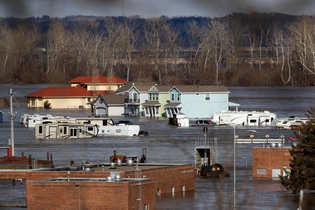
River levels hit all-time highs near Valley, Waterloo, forcing road closures, evacuations
Water levels rose to all-time highs Friday along portions of the Elkhorn and Platte Rivers in western Douglas County.
Nothing described the severity of the situation better than the fact that the office of the National Weather Service in Valley, which provided critical information on the evolving flood situation, was itself evacuating.
The weather service office in Hastings took over for the Valley office.
“We’re backing them up,” Shawn Rossi, a meteorologist in Hastings, said shortly before 11 a.m. “They’re shutting down power and leaving.”
The Platte peaked at 12.63 feet at the Leshara gauge, more than 7 inches above major flood status and more than 9 inches above the previous record, set in February 1996, according to the National Oceanic and Atmospheric Administration.
The Waterloo gauge of the Elkhorn read 24.11 feet at 4:15 p.m., well above major flood status and about 5 feet above the previous record set in March 1962. NOAA projections indicated that Elkhorn River levels could start to decrease Friday night. Platte levels near Valley were trending slightly downward Friday afternoon.
Friday proved to be an alarming day for some in eastern Nebraska.
Officials declared a flood emergency for western Douglas County and parts of Dodge and Saunders Counties after the Union Dike on the Platte River failed.
The National Weather Service issued an alert at 10:18 a.m. and called for people to evacuate the Valley area immediately, saying flash flooding was imminent. The weather service described the flood potential in parts of western Douglas County as “extremely dangerous and life-threatening.”
Near Waterloo, farmer John Lamprecht stood on his property on the southeast corner of Highway 275 and Blondo Street. He trained binoculars on water that had overflowed from the Elkhorn River near his house.
By Friday evening, Lamprecht said 3 inches of water had snaked into his machine shed. “It’s amazing to look outside and see that much water,” he said. He and his wife expected their home and garage to remain above the water.
At Christian Church of Waterloo, Pastor Mike Bitter and his wife, Ruth, stood ready to help anyone.
They prepared to act as a shelter Friday or a collection point for food, clothing and other supplies. They planned to make chili and cook frozen pizzas.
For days, emergency responders have been warning residents in Valley to evacuate, said Capt. Wayne Hudson with the Douglas County Sheriff’s Office.
Hudson said rescue crews have lost airboats and put themselves at risk to help residents evacuate.
“We went through with bullhorns, P.A. systems, the whole nine yards, telling them to evacuate,” he said. “They didn’t heed our warning.”
Crews Friday morning closed the West Dodge Expressway going west, just past the Elkhorn exit, 204th Street.
Road closures made it harder for officials to determine where problem spots were on levees and dikes, said John Winkler, the general manager for the Papio-Missouri River NRD.
“We can’t get people out to survey without getting them caught there or where they can’t get back,” he said. “Right now, we’re just in monitoring mode. There’s nothing we can do to shore up any levees. The only thing we can do is help keep people notified and out of harm’s way.”
Between 7:30 a.m. and 10:30 a.m. Friday, Orchard Gardens assisted living center in Valley had evacuated 47 residents.
Rita Argintean sat in front of the Orchard Gardens door with all the belongings she could rustle together.
The 84-year-old had survived two prior floods in Valley but was not sticking around for the third.
“I hate ’em,” she said. “It’s horrible.”
By 11 a.m., all 53 residents had been evacuated.
Kris Pryor, director of senior housing, said the facility had not flooded as of Friday morning. But Pryor said officials chose to evacuate because of the risk of losing power to the facility. She said she doesn’t expect residents to return before Monday.
Argintean said she wasn’t sure where she would land but said she probably would end up with one of her nieces.
Winkler, with the NRD, called the flooding “unprecedented.” It’s all the more remarkable, he said, considering it wasn’t prompted by a 100-year storm or massive, days-long rains.
“I’m hoping this isn’t a new norm,” he said. “It was cold, snowy winter weather, and we had some spring rain.”
If there is a bright spot, Winkler said dams, reservoirs and levees in the greater Omaha metro area were holding up.
“We’re not expecting any issues outside the major river basins,” he said. “Now we’re just worried about the Elkhorn, Missouri and the Platte.”
World-Herald staff writers Erin Duffy, Nancy Gaarder, Chris Peters, Erin Grace and Roseann Moring contributed to this report.