BROKEN BOW – The Broken Bow City Council convened on Tuesday, June 14 with a near singular focus: the plans for potential redevelopment of two areas within city limits.
Both areas, according to Bobbi Pettit of Five Rule Rural Planning, meet the State of Nebraska’s Community Development classification of blighted and substandard areas, an ominous-sounding label, but one that is not without hope.
Dan Knoell, City Administrator for Broken Bow, assured the council and those present: “Some of the information it sounded like a bunch of negative stuff – it was. But it’s good for the community, obviously, to know this and to think of different ways to fix and repair moving forward.”
The Blight and Substandard Study plants the seed of potential for growth and development within Broken Bow, inviting otherwise unattainable investment through Tax Increment Funding (TIF), among other possible sources.
Dan Knoell: “In the last 10 years, $3.7 million through TIF, which this will eventually lead to, potentially, has helped develop, grow, and move Broken Bow in the correct and forward direction. So I want you guys to hold that number when you make these decisions for the remainder of the night on what blight/substandard truly means: $3.7 million worth of projects potentially could not have happened without a blight/substandard ruling.”
Based on the information Pettit collected from the Custer County Assessor’s property records, most structures in both redevelopment areas fit the Nebraska State Legislature’s definition of blighted: an area possessing a combination of factors that substantially impairs or arrests sound growth of a community. The dilapidation of structures is merely one factor among many.
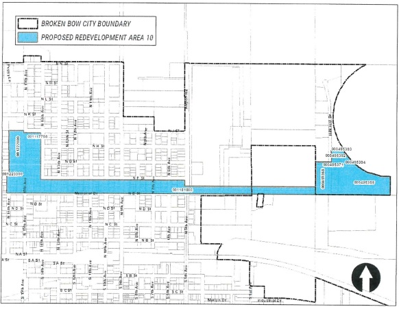
The first area, dubbed “Area 10,” claims Memorial Drive as its southern boundary, stretches northward to F Street on the western side of Broken Bow, and follows a portion of Hillcrest Drive to the east. According to Pettit’s study, the average year for construction of the 88 structures within the area was 1946, 86% of which were built before 1981.
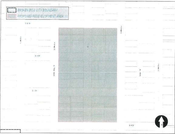
Area 11 occupies several blocks between Highway 21 and South 6th Avenue, with South G and K Streets as its respective north/south borders. According to the study, the average age of the 30 residential and commercial structures within the area is 96, 23 of which were built between 1900 and 1940.
The council approved unanimously to designate both areas for redevelopment, though no further specific action has been taken.
According to Pettit: “Having a general redevelopment plan, it will go smoother when entertaining a redevelopment project within the blighted area.”
Additionally, the council passed Resolution 2022-7, approving the Lot Split for Michael R. Garner and Mary Jane Garner at 1131 North G Street, and approved the meeting minutes from May 24, its bills, and Loud & Proud Fireworks, LLC. The next City Council meeting is slated for June 28, 2022, at 6 p.m.