


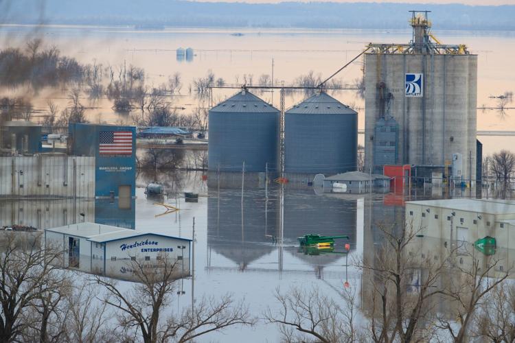
Rainfall records continue to break during this soggy year, and as a result, the ongoing risk of flooding continues, along with worries about high river levels and road closures.
Nebraska, Kansas and Missouri had their wettest May on record, and Iowa had its fourth-wettest May, according to the National Centers for Environmental Information. The month was wet across the country, with the lower 48 states seeing their second-wettest May on record, the centers announced Thursday. Records date back 125 years.
Saturated soils are contributing to the flooding. Federal officials said precipitation over the last 12 months was higher, by far, than any previous June through May on record. Indeed, it’s the highest of any 12-month stretch in the last 125 years for the lower 48 states. On average, across the U.S., 37.68 inches fell over the last 12 months. That’s 7.73 inches above average.
As a result of all this rain, the footprint of drought across the lower 48 states is one of the smallest on record.
The near-record and record amounts of rain in the heartland have worsened flooding along the Missouri River, caused additional damage to levees and slowed repairs, said John Leighow, chief of readiness and contingency operations in the Army Corps of Engineers. It was only this week that the corps was able to get back to repairing damaged levees in southwest Iowa, he said.
“The rains have not let up much since March,” Leighow said.
Runoff feeding into the six massive upstream dams in May was three times the average and second only to May 2011, the trigger to that year’s devastating flood. Additionally, in the area between Gavins Point Dam and Sioux City, Iowa, an area where there is no reservoir to control flooding, runoff last month was the highest on record.
The U.S. Climate Prediction Center is forecasting a wetter than normal summer, and if that forecast bears out, the risk of flooding will persist, said Kevin Low, a hydrologist at the agency.
If there’s any good news in the short term, it’s that the forecast calls for mostly scattered storms over the next week, rather than widespread, heavy rains.
Another bit of short-term good news is that the Missouri River has crested along most of the Nebraska-Iowa border for now. A gradual drop is forecast, unless new rains reverse that.
Given the records that have been set already and the likelihood of a wet summer, the corps is estimating that runoff feeding into the reservoirs on the upper Missouri River will end up being the second-highest on record, said Kevin Grode, who oversees reservoir regulation. Runoff could end up being almost double normal, he said Thursday.
That’s not good news for communities and farmers along the Missouri River. The corps expects to keep releases from Gavins Point at 75,000 cubic feet per second into at least early July, said Mike Swenson of the corps. That’s more than double normal. Sometime in July, if rainfall permits, releases will drop — but they won’t drop back to normal, Swenson said. The corps expects releases from Gavins Point to remain above average into the fall.
It’s still not known when travelers can expect to see a reopening of highways and Interstates closed by flooding, said Scott Suhr of the Iowa Department of Transportation.
Long stretches of Interstate 29 are closed in Iowa, as are several major bridges over the Missouri River.
“We don’t know when the river is going to recede, and we don’t know what kind of damage is under the water,” he said. “Once it recedes, we’ll evaluate the pavement, remove the debris, and open the roads as quickly and safely as possible.”
Omaha ratchets up flood protections — just in case Missouri River rises more
The City of Omaha is ramping up its flood preparations, just in case this summer takes a turn for the worse.
Pulling a page from the devastating flood of 2011, the city is:
- Placing pumps along the levee and elsewhere so that runoff can be pumped out of the city and into the Missouri River. This will reduce the amount of runoff pouring into the city’s sewage system during heavy rains. Additional pumps are being placed at key spots along the city’s sewer system so that water that backs into the system from the river can be forced on down the line and toward the sewage plant, said Jim Theiler, assistant director of environmental services in the Public Works Department. These measures will better ensure that sewage can flow through the system to the treatment plant, he said.
- Notifying property owners along the river of any drainage problems and keeping them abreast of the city’s actions.
- Forming an Incident Command Center, an important organizational step taken during disasters to provide a chain of command, reduce miscommunication and speed decision-making. Public Works, the Omaha Fire Department and the Douglas County Emergency Management Agency are forming the team.
Missouri River crests — for now — at 31.97 feet
The Missouri River crested at 31.97 feet Wednesday in Omaha and is projected to continue slowly dropping, according to the National Weather Service.
Wednesday’s crest was the third-highest since the massive upstream dams were completed in the early 1960s. The highest crest occurred July 2, 2011, at 36.29 feet. The second-highest occurred earlier this spring, when the river crested about 2.5 feet higher than it did this week, reaching 34.41 feet on March 17.
Barring significant rains, the river could drop to minor flood stage in Omaha next week, according to the weather service. But city officials say problems could still occur during heavy rains. Even when the river is below minor flood stage, 29 feet, local rains could cause it to rise 2 feet or more, Omaha officials said. Should that occur, the city would be prepared to close the floodgates if needed.
EPA offers loans for water infrastructure repair
Three Midlands communities are getting a jump-start on funding flood-related projects through the Environmental Protection Agency.
The EPA has signed an agreement with the Federal Emergency Management Agency to provide loans to communities for water quality infrastructure repairs. Those include such things as repairs to water treatment plants, sewage plants and pipes.
Communities will be able to apply for low- or no-cost loans from the EPA to fill in gaps while they wait for FEMA money to come in. (The FEMA money would reimburse the loan.)
The first to use this new assistance are Hamburg and Glenwood in Iowa and Boyd County in Nebraska.